Surveying, Mapping & GIS

From precise field measurements to digital solutions for design and management. We provide a full cycle: from high-precision geodetic surveys, aerial photography, and laser scanning to ready-to-use digital products (orthophoto maps, topographic plans, geodata databases, GIS solutions).
Our validated geodata and maps become the reliable foundation for strategic planning, design, asset management, and investment decision-making.
Using modern software such as ArcGIS and ArcGIS Pro, we transform data into precise digital solutions that comply with state and international standards.
Areas
Using modern software such as ArcGIS and ArcGIS Pro, we transform data into precise digital solutions that comply with state and international standards.

Case Studies

Exceptional results in complex projects

Digital Topographic Base at a Scale of 1:500 for a Land Plot in Odesa Oblast

The Archizem team produced a digital topographic base at a scale of 1:500 for a land plot in Odesa Oblast to deliver accurate source data for engineering design documentation.
SEE DETAILS

Topographic Base at a Scale of 1:500 for a Land Plot in Chernihiv Oblast

The Archizem team produced a digital topographic base at a scale of 1:500 for a land plot in Chernihiv Oblast. The work was carried out to provide reliable geospatial data for the preparation of design documentation for construction and related engineering purposes.
SEE DETAILS

Services

01

Surveying

Accuracy from the first measurement in the field to the creation of the final plan. We provide the full cycle of engineering-geodetic works, transforming field data into a reliable digital foundation for your project.

Our work encompasses:
- engineering-geodetic surveys of any complexity, high-precision measurements, and stakeouts using modern surveying equipment;
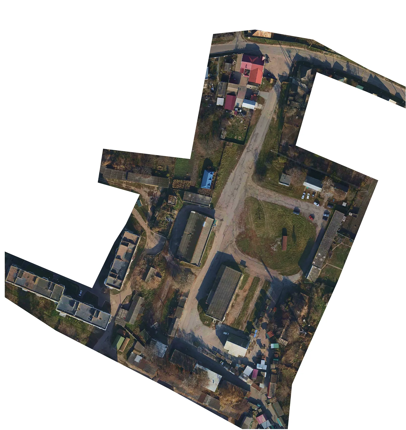
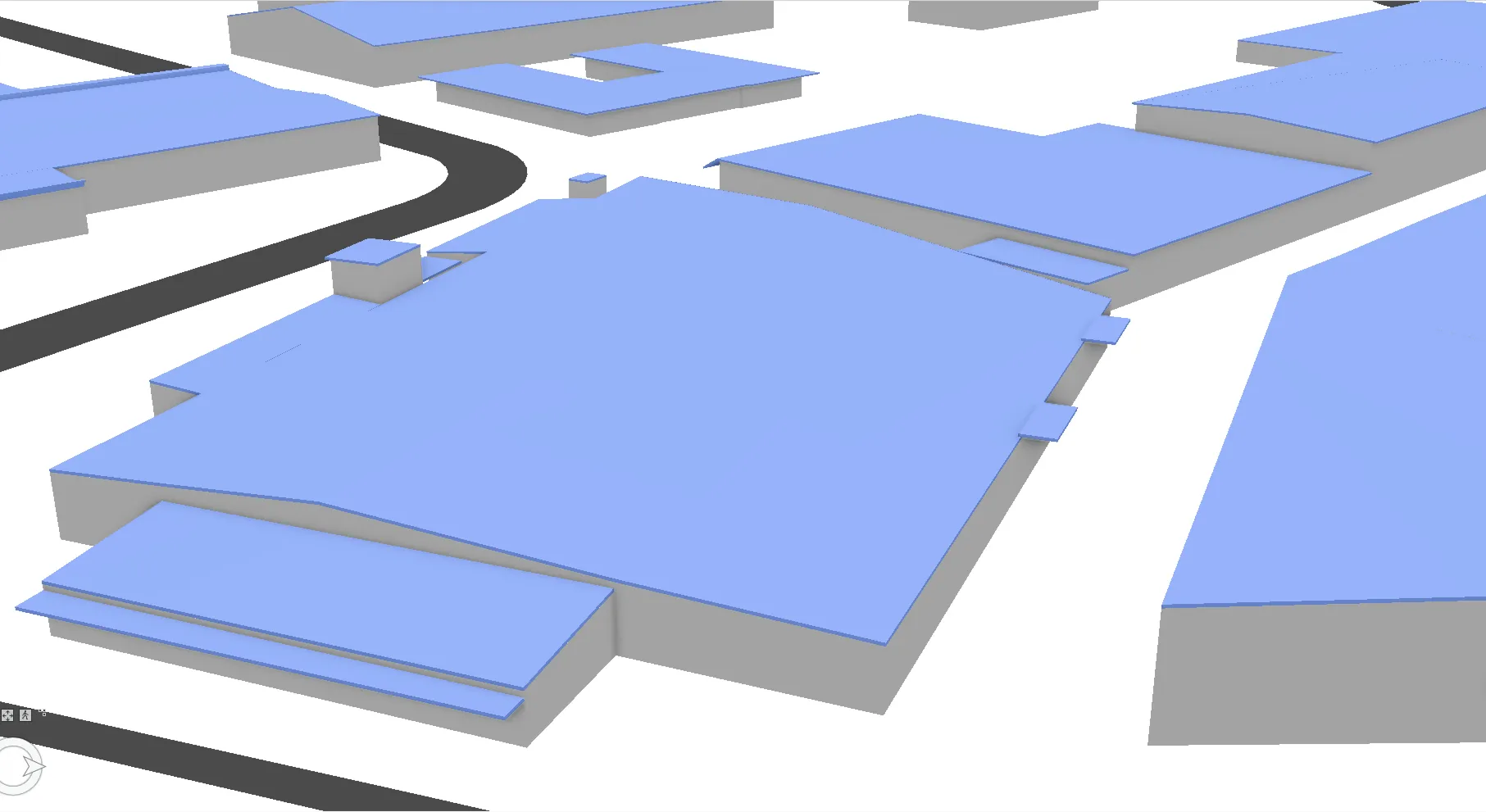
- aerial photography and laser scanning (LiDAR) to obtain detailed orthophoto maps, Digital Terrain Models (DTM), and Digital Elevation Models (DEM).

Extensive experience working on industrial sites, infrastructure facilities, and in dense urban development allows our specialists to guarantee data reliability even in the most challenging conditions.

The result for you is not just a report, but:
- accurate geodetic documentation for design and permitting;
- digital models for calculations, planning, and analysis;
- a reliable geodetic basis for construction, installation, or object monitoring.

We ensure full quality control at all stages, guaranteeing that every millimeter on the plan corresponds to a real centimeter on the ground.

Execution Stages:

Technical Specification Alignment

Definition and fixation of the main parameters: work objectives, required scale, permissible tolerances, coordinate system, and specifications of the final deliverables.
01

Execution of Field Geodetic Works

Executing measurements using the optimal method: total station surveys, GNSS observations, or UAV-based aerial photography/laser scanning. The choice depends on the specific object and the task at hand, whether it requires point measurements, dense point clouds, or orthophoto maps.
02

Office Processing and Data Preparation

Office processing of field measurement results: mathematical processing and adjustment, creation of digital models, coordinate transformation. Control of internal consistency and quality of the obtained data arrays.
03

Generation of Output Materials and Models

Creation of final products based on the processed data: topographic plans (site plans), digital terrain models (DTM), digital elevation models (DEM), etc. Export of results into the specified vector (.dwg, .dxf, .dgn) or raster formats.
04

Final Quality Control and Handover of Results

Comprehensive verification of geometric accuracy, information completeness, and compliance of all products with the technical specification requirements. Handover to the client of the complete set of output materials, models, and documentation in the agreed manner.
05

Services

02

Mapping

We transform environmental data into clear maps for decision-making. We develop modern digital and analog topographic maps and plans that become the visual and analytical foundation for your project.

Based on data from geodetic measurements, aerial photography, and satellite imagery, we create:
- topographic maps and plans for detailed design and construction.
- cadastral maps for legally precise representation of land plots.
- thematic maps (engineering, environmental, planning) for analyzing specific territorial parameters.

We perform detailed vectorization of terrain objects (converting images into digital objects), generalization (adapting the level of detail to the appropriate scale), and professional cartographic design. The result is clean, structured vector graphics ready for seamless import into your GIS systems, CAD environments, and analytics platforms.

Execution Stages:

Alignment of Technical Specification and Analysis of Source Materials

Definition of the map's theme, target scale (spatial resolution), required set of layers, and output formats. Expert assessment of available source data regarding its suitability, relevance, and metric foundation.
01

Preliminary Processing and Transformation of Source Data

Execution of georeferencing for raster base maps, coordinate harmonization of heterogeneous vector data, and their transformation into a unified project coordinate system to ensure the metric accuracy of all materials.
02

Thematic Vectorization and Attribute Enrichment

Creation of vector layers through the interpretation and digitization of terrain objects according to the technical specification's classification schema. Enrichment of objects with semantic information (attributes).
03

Field Verification (Ground Truthing / Field Interpretation)

Expert refinement and correction of cartographic object parameters (contours, types, characteristics) through visual inspection and instrumental verification directly on-site.
04

Office Integration of Field Verification Results

Integration of the obtained field data into the digital model: implementation of corrective edits to the geometry and attributes of vector layers.
05

Comprehensive Data Validation and Quality Control

Systematic verification of the created geodatabase for topological integrity, completeness of attribute data, logical consistency of layers, and compliance with the technical specification requirements.
06

Final Design and Delivery of Results to the Client

Finalizing the cartographic composition to required standards and delivering the results in agreed formats: vector (.shp, .gdb, .dwg, .dmf), raster (.geotiff, .pdf), or as a print-ready layout with accompanying documentation.
07

Services

03

Geographic Information Systems (GIS)

We transform disparate data into a unified management system. We design, implement, and populate corporate Geographic Information Systems (GIS) that consolidate all spatial information about your assets into a single, intuitively understandable tool.

Our work includes:
- designing and developing the structure of a geospatial database (GDB) tailored to your specific needs.
- comprehensive population of the GDB: from vectorization and object inventory to integrating data from surveying, mapping, cadastre, and internal systems.
- creating web applications and analytics tools based on the ArcGIS platform, providing convenient access, visualization, and data processing capabilities for all departments.

Execution Stages:

Technical Specification Alignment

Definition of the goals and functional requirements for the geodatabase, data types and sources, layer structure, classification system, and final product formats. Coordination of the database architecture.
01

Integration and Preparation of Source Data

Import and consolidation of heterogeneous source data. Execution of a set of preparatory operations: georeferencing, coordinate transformation, standardization to unified specifications for further processing.
02

Structured Vectorization and Geodatabase (GDB) Formation

Vectorization through object digitization and formation of thematic layers. Enrichment of layers with semantic information and establishment of logical connections. Data correction and topological optimization.
03

Cartographic Visualization and Design

Generation of maps based on the created geodatabase according to the client's requirements. Professional cartographic design: development of a legend, application of symbols and labels, compositional layout.
04

Comprehensive Validation and Quality Control

Thorough verification of the geodatabase and cartographic products for compliance with the technical specification: control of metric accuracy, topological integrity, completeness of attributes, and logical consistency of all layers.
05

Finalization, Export, and Handover of Results

Export of geodatabases (.gdb, GeoPackage), vector or graphic files. Delivery of the complete set to the client along with documentation for further use in GIS and web environments.
06

Free data audit and calculation — within 24 hours.

Submit your request

Our specialists will conduct a free analysis of your source data and provide a detailed proposal with cost and timelines within one business day.
Grazie! Your submission has been received!
We have received your request and will contact you shortly
Oops! Something went wrong. Please try again.
0
%